Papers with Code 아카이브

Image Segmentation

태스크의 하위 분류와 논문·코드·평가·기법·데이터셋을 탐색하세요.

하위 태스크
1
평가표
13
보존된 평가 기록
34

Image Segmentation is a computer vision task that involves dividing an image into multiple segments or regions, each of which corresponds to a different object or part of an object. The goal of image segmentation is to assign a unique label or category to each pixel in the image, so that pixels with similar attributes are grouped together.

데이터셋

출처에 같은 태스크 이름으로 연결된 데이터셋입니다. 동명 태스크가 포함될 수 있으므로, 비교할 때는 평가 결과의 조건도 확인하세요.

ImageNet

The ImageNet dataset contains 14,197,122 annotated images according to the WordNet hierarchy. Since 2010 the dataset is used in the ImageNet Large Scale Visual Recognition Challenge (ILSVRC), a benchmark in image classification and object detection. The publicly released dataset contains a set of manually annotated training images. A set of test images is also released, with the manual annotations withheld. ILSVRC annotations fall into one of two categories: (1) image-level annotation of a binary label for the presence or absence of an object class in the image, e.g., “there are cars in this image” but “there are no tigers,” and (2) object-level annotation of a tight bounding box and class label around an object instance in the image, e.g., “there is a screwdriver centered at position (20,25) with width of 50 pixels and height of 30 pixels”. The ImageNet project does not own the copyright of the images, therefore only thumbnails and URLs of images are provided. * Total number of non-empty WordNet synsets: 21841 * Total number of images: 14197122 * Number of images with bounding box annotations: 1,034,908 * Number of synsets with SIFT features: 1000 * Number of images with SIFT features: 1.2 million Source: ImageNet Large Scale Visual Recognition Challenge Image Source: https://cs.stanford.edu/people/karpathy/cnnembed/

PASCAL VOC

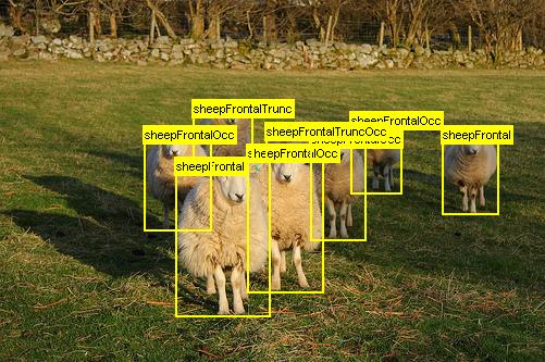
The PASCAL Visual Object Classes (VOC) 2012 dataset contains 20 object categories including vehicles, household, animals, and other: aeroplane, bicycle, boat, bus, car, motorbike, train, bottle, chair, dining table, potted plant, sofa, TV/monitor, bird, cat, cow, dog, horse, sheep, and person. Each image in this dataset has pixel-level segmentation annotations, bounding box annotations, and object class annotations. This dataset has been widely used as a benchmark for object detection, semantic segmentation, and classification tasks. The PASCAL VOC dataset is split into three subsets: 1,464 images for training, 1,449 images for validation and a private testing set. Source: Self-supervised Visual Feature Learning with Deep Neural Networks: A Survey Image Source: http://host.robots.ox.ac.uk/pascal/VOC/voc2012/examples/images/sheep_06.jpg

SA-1B

SA-1B consists of 11M diverse, high resolution, licensed, and privacy protecting images and 1.1B high-quality segmentation masks. Source: Segment Anything Image Source: Segment Anything

MCubeS

Multimodal material segmentation (MCubeS) dataset contains 500 sets of images from 42 street scenes. Each scene has images for four modalities: RGB, angle of linear polarization (AoLP), degree of linear polarization (DoLP), and near-infrared (NIR). The dataset provides annotated ground truth labels for both material and semantic segmentation for every pixel. The dataset is divided training set with 302 image sets, validation set with 96 image sets, and test set with 102 image sets. Each image has 1224 x 1024 pixels and a total of 20 class labels per pixel.

PMD

We propose a large-scale benchmark here, which contains a total of 6,461 mirror images with ground truth annotations.

WildScenes

WildScenes is a bi-modal benchmark dataset consisting of multiple large-scale, sequential traversals in natural environments, including semantic annotations in high-resolution 2D images and dense 3D LiDAR point clouds, and accurate 6-DoF pose information. The data is (1) trajectory-centric with accurate localization and globally aligned point clouds, (2) calibrated and synchronized to support bi-modal training and inference, and (3) containing different natural environments over 6 months to support research on domain adaptation. We introduce benchmarks on 2D and 3D semantic segmentation and evaluate a variety of recent deep-learning techniques to demonstrate the challenges in semantic segmentation in natural environments. We propose train-val-test splits for standard benchmarks as well as domain adaptation benchmarks and utilize an automated split generation technique to ensure the balance of class label distributions. The WildScenes benchmark webpage is https://csiro-robotics.github.io/WildScenes, and the data is publicly available at https://data.csiro.au/collection/csiro:61541 .

EntitySeg

The EntitySeg dataset contains 33,227 images with high-quality mask annotations. Compared with existing dataets, there are three distinct properties in EntitySeg. First, 71.25% and 86.23% of the images are of high resolution with at least 2000px×2000px and 1000px×1000px which is more consistent with current digital imaging trends. Second, the dataset is open-world and is not limited to predefined classes. Third, the mask annotation along the boundaries are more accurate than existing datasets. Source: Fine-Grained Entity Segmentation Image Source: https://arxiv.org/pdf/2211.05776v1.pdf

CheXmask

The CheXmask Database presents a comprehensive, uniformly annotated collection of chest radiographs, constructed from five public databases: ChestX-ray8, Chexpert, MIMIC-CXR-JPG, Padchest and VinDr-CXR. The database aggregates 657,566 anatomical segmentation masks derived from images which have been processed using the HybridGNet model to ensure consistent, high-quality segmentation. To confirm the quality of the segmentations, we include in this database individual Reverse Classification Accuracy (RCA) scores for each of the segmentation masks. This dataset is intended to catalyze further innovation and refinement in the field of semantic chest X-ray analysis, offering a significant resource for researchers in the medical imaging domain.

MARIDA

MARIDA (Marine Debris Archive) is the first dataset based on the multispectral Sentinel-2 (S2) satellite data, which distinguishes Marine Debris from various marine features that co-exist, including Sargassum macroalgae, Ships, Natural Organic Material, Waves, Wakes, Foam, dissimilar water types (i.e., Clear, Turbid Water, Sediment-Laden Water, Shallow Water), and Clouds. MARIDA is an open-access dataset which enables the research community to explore the spectral behaviour of certain floating materials, sea state features and water types, to develop and evaluate Marine Debris detection solutions based on artificial intelligence and deep learning architectures, as well as satellite pre-processing pipelines. Although it is designed to be beneficial for several machine learning tasks, it primarily aims to benchmark weakly supervised pixel-level semantic segmentation learning methods. MARIDA can be downloaded from the repository Zenodo (https://doi.org/10.5281/zenodo.5151941). A quick start guide for all ML benchmarks and the detailed overview of the dataset are available at https://marine-debris.github.io/.

2DeteCT

Maximilian B. Kiss, Sophia B. Coban, K. Joost Batenburg, Tristan van Leeuwen, and Felix Lucka "2DeteCT - A large 2D expandable, trainable, experimental Computed Tomography dataset for machine learning", Sci Data 10, 576 (2023) or arXiv:2306.05907 (2023) Abstract: "Recent research in computational imaging largely focuses on developing machine learning (ML) techniques for image reconstruction, which requires large-scale training datasets consisting of measurement data and ground-truth images. However, suitable experimental datasets for X-ray Computed Tomography (CT) are scarce, and methods are often developed and evaluated only on simulated data. We fill this gap by providing the community with a versatile, open 2D fan-beam CT dataset suitable for developing ML techniques for a range of image reconstruction tasks. To acquire it, we designed a sophisticated, semi-automatic scan procedure that utilizes a highly-flexible laboratory X-ray CT setup. A diverse mix of samples with high natural variability in shape and density was scanned slice-by-slice (5000 slices in total) with high angular and spatial resolution and three different beam characteristics: A high-fidelity, a low-dose and a beam-hardening-inflicted mode. In addition, 750 out-of-distribution slices were scanned with sample and beam variations to accommodate robustness and segmentation tasks. We provide raw projection data, reference reconstructions and segmentations based on an open-source data processing pipeline." The data collection has been acquired using a highly flexible, programmable and custom-built X-ray CT scanner, the FleX-ray scanner, developed by TESCAN-XRE NV, located in the FleX-ray Lab at the Centrum Wiskunde & Informatica (CWI) in Amsterdam, Netherlands. It consists of a cone-beam microfocus X-ray point source (limited to 90 kV and 90 W) that projects polychromatic X-rays onto a 14-bit CMOS (complementary metal-oxide semiconductor) flat panel detector with CsI(Tl) scintillator (Dexella 1512NDT) and 1536-by-1944 pixels, each. To create a 2D dataset, a fan-beam geometry was mimicked by only reading out the central row of the detector. Between source and detector there is a rotation stage, upon which samples can be mounted. The machine components (i.e., the source, the detector panel, and the rotation stage) are mounted on translation belts that allow the moving of the components independently from one another. Please refer to the paper for all further technical details. The complete data collection can be found via the following links: 1-1,000, 1,001-2,000, 2,001-3,000, 3,001-4,000, 4,001-5,000, 5,521-6,370. Each slice folder ‘slice00001 - slice05000’ and ‘slice05521 - slice06370’ contains three folders for each mode: ‘mode1’, ‘mode2’, ‘mode3’. In each of these folders there are the sinogram, the dark-field, and the two flat-fields for the raw data archives, or just the reconstructions and for mode2 the additional reference segmentation. The corresponding reference reconstructions and segmentations can be found via the following links: 1-1,000, 1,001-2,000, 2,001-3,000, 3,001-4,000, 4,001-5,000, 5,521-6,370. The corresponding Python scripts for loading, pre-processing, reconstructing and segmenting the projection data in the way described in the paper can be found on github. A machine-readable file with the used scanning parameters and instrument data for each acquisition mode as well as a script loading it can be found on the GitHub repository as well. Note: It is advisable to use the graphical user interface when decompressing the .zip archives. If you experience a zipbomb error when unzipping the file on a Linux system rerun the command with the UNZIP_DISABLE_ZIPBOMB_DETECTION=TRUE environment variable by setting in your .bashrc “export UNZIP_DISABLE_ZIPBOMB_DETECTION=TRUE”. For more information or guidance in using the data collection, please get in touch with Maximilian.Kiss [at] cwi.nl Felix.Lucka [at] cwi.nl
MSD (Mirror Segmentation Dataset)

We construct the first large-scale mirror dataset, named MSD. It includes 4, 018 pairs of images containing mirrors and their corresponding manually annotated masks.

MAS3K

MAS3K contains a total of 3,103 images, where 1,588 are for camouflaged cases, 1,322 are for common cases, and 193 are underwater images in absence of marine animals. The marine animal categories in MAS3K cover both vertebrate and invertebrate, including seven super-classes, e.g., mammals, reptile, arthropod, and marine fish, etc. Under the super-classes, MAS3K dataset has 37 sub-classes, e.g., crab, starfish, shark, and turtle, etc.

RMAS

We construct a new large-scale real-world MAS data set for conducting extensive experiments. It consists of over 3000 images with various underwater scenes and objects. Each image is annotated with an object-level mask and assigned to a category.

USIS10K

We construct the first large-scale dataset, USIS10K, for the underwater salient instance segmentation task, which contains 10,632 images and pixel-level annotations of 7 categories. As far as we know, this is the largest salient instance segmentation dataset, and includes Class-Agnostic and Multi-Class labels simultaneously. If you use this dataset in your work, please consider to cite: @inproceedings{ lian2024icml, title={Diving into Underwater: Segment Anything Model Guided Underwater Salient Instance Segmentation and A Large-scale Dataset}, author={Shijie Lian and Ziyi Zhang and Hua Li and Wenjie Li and Laurence Tianruo Yang and Sam Kwong and Runmin Cong}, booktitle={Forty-first International Conference on Machine Learning}, year={2024}, url={https://openreview.net/forum?id=snhurpZt63} }

UIIS10K

We propose a large-scale underwater instance segmentation dataset, UIIS10K, which includes 10,048 images with pixel-level annotations for 10 categories. As far as we know, this is the largest underwater instance segmentation dataset available and can be used as a benchmark for evaluating underwater segmentation methods.

CaBuAr

This dataset contains images from Sentinel-2 satellites taken before and after a wildfire. The ground truth masks are provided by the California Department of Forestry and Fire Protection and they are mapped on the images. The dataset is designed to do binary semantic segmentation of burned vs unburned areas.

EVD4UAV

VD4UAV is an altitude-sensitive benchmark dataset designed to evade vehicle detection in Unmanned Aerial Vehicle (UAV) imagery. This dataset is specifically curated to facilitate the study of adversarial patch-based vehicle detection attacks in UAV images. The EVD4UAV dataset comprises a diverse set of images captured at various altitudes with fine-grained annotations, making it a robust platform for evaluating the performance of object detectors under adversarial conditions. Notably, the dataset includes around 3,000 images depicting winter scenarios where vehicles may be partially or fully covered by snow, providing a unique challenge for vehicle detection algorithms.

Pothole Mix

This dataset for the semantic segmentation of potholes and cracks on the road surface was assembled from 5 other datasets already publicly available, plus a very small addition of segmented images on our part. To speed up the labeling operations, we started working with depth cameras to try to automate, to some extent, this extremely time-consuming phase. The main dataset is composed of 4340 (image,mask) pairs at different resolutions divided into training/validation/test sets with a proportion of 3340/496/504 images equal to 77/11/12 percent. This is the dataset used in the SHREC2022 competition and it is the dataset that allowed us to train the neural networks for semantic segmentation capable of obtaining the nice images and videos that you have probably already seen. Along the main dataset we also release a set of RGB-D videos consisting of 797 RGB clips and as many clips with their disparity maps, captured with the excellent OAK-D cameras we won for being finalists at the OpenCV AI Competition 2021. In an effort to achieve (semi-)automatic labeling for these clips, we postprocessed the disparity maps using classic CV algorithms and managed to obtain 359 binary mask clips. Obviously these masks are not perfect (they cannot be by definition, otherwise the problem of automatic road damage detection would not exist), but nonetheless we believe they are an excellent starting point to create, for example, new data augmentations (creating potholes on "intact road images" belonging to other standard road datasets) or to be used as textures in the creation of 3D scenes from which to extract large amounts of images/masks for the training of neural networks. You can have a preview of what you will find in these clips by watching this video showing the overlay of images and binary masks: http://deeplearning.ge.imati.cnr.it/genova-5G/video/pothole-mix-videos/pothole-mix-rgb-d-overlay-videos-concat.html Please take a look at the readme file inside the main dataset zipfile to have some more details about the single sub-datasets and their sources.

BD-TypoSAT

On Sunday, August 29, 2021, Hurricane Ida struck parts of Louisiana and Mississippi with wind gusts reaching up to 172 mph, leaving more than a million customers without electricity, including the entire New Orleans area. During the disaster, Maxar captured high spatial resolution satellite imagery (at 0.4 m/pixel) and was subsequently made publicly available. The original images were segmented into 512*512-pixel patches to maintain spatial context while enabling detailed analysis. From this process, we generated a dataset of 2,135 triplets, each containing a pre-disaster image, a post-disaster image, and a manually annotated damage categorical mask.

ENSeg

ENSeg Dataset Overview This dataset represents an enhanced subset of the ENS dataset. The ENS dataset comprises image samples extracted from the enteric nervous system (ENS) of male adult Wistar rats (Rattus norvegicus, albius variety), specifically from the jejunum, the second segment of the small intestine. The original dataset consists of two classes: - Control (C): Healthy animals. - Walker-256 Tumor (WT): Animals with cancer induced by the Walker-256 Tumor. Image acquisition involved 13 different animals, with 7 belonging to the C class and 6 to the WT class. Each animal contributed 32 image samples obtained from the myenteric plexus. All images were captured using the same setup and configuration, stored in PNG format, with a spatial resolution of 1384 × 1036 pixels. The overall process of obtaining the images and performing the morphometric and quantitative analyses takes approximately 5 months. ### Dataset Annotations Our dataset version includes expert-annotated labels for 6 animals, tagged as 2C, 4C, 5C, 22WT, 23WT, and 28WT. The image labels were created by members of the same laboratory where the images originated: researchers from the Enteric Neural Plasticity Laboratory of the State University of Maringá (UEM). Annotations were generated using LabelMe and consist of polygons marking each neuron cell. To maintain labeling quality according to laboratory standards, only neuron cells with well-defined borders were included in the final label masks. The labeling process lasted 9 months (from November 2023 to July 2024) and was iteratively reviewed by the lead researcher of the lab. ### Dataset Statistics After processing, the full dataset contains: - 187 images - 9,709 annotated neuron cells The table below summarizes the number of images and annotated neurons per animal tag. | Animal Tag | # of Images | # of Neurons | |------------|------------|--------------| | 2C | 32 | 1590 | | 4C | 31 | 1513 | | 5C | 31 | 2211 | | 22WT | 31 | 1386 | | 23WT | 31 | 1520 | | 28WT | 31 | 1489 | | Total | 187 | 9709 | ### Recommended Training Methodology Due to the limited number of animal samples and the natural split of images, we recommend using a leave-one-out cross-validation (LOO-CV) method for training. This ensures more reliable results by performing six training sessions per experiment, where: - In each session, images from one subject are isolated for testing. - The remaining images are used for training. Although cross-validation is recommended, it is not mandatory. Future works may introduce new training methodologies as the number of annotated subjects increases. However, it is crucial to maintain images from the same source (animal) within the same data split to prevent biased results. Even though samples are randomly selected from the animals' original tissues, this approach enhances the credibility of the findings. This dataset provides a valuable resource for instance segmentation and biomedical image analysis, supporting research on ENS morphology and cancer effects. Contributions and feedback are welcome! ## Project Citation If you want to cite our article, the dataset, or the source codes contained in this repository, please used the citation (bibtex format): @Article{felipe25enseg, AUTHOR = { Felipe, Gustavo Zanoni and Nanni, Loris and Garcia, Isadora Goulart and Zanoni, Jacqueline Nelisis and Costa, Yandre Maldonado e Gomes da}, TITLE = {ENSeg: A Novel Dataset and Method for the Segmentation of Enteric Neuron Cells on Microscopy Images}, JOURNAL = {Applied Sciences}, VOLUME = {15}, YEAR = {2025}, NUMBER = {3}, ARTICLE-NUMBER = {1046}, URL = {https://www.mdpi.com/2076-3417/15/3/1046}, ISSN = {2076-3417}, DOI = {10.3390/app15031046} } ## Additional Notes Please check out our previous datasets if you are interest into developing projects with Enteric Nervous System images: 1. EGC-Z: three datasets of Enteric Glial cells images, composed of three different chronic degenerative diseases: Cancer, Diabetes Mellitus, and Rheumatoid Arthritis. Each dataset represent binary classification task, with the classes: control (healthy) and sick; 2. ENS: the ENS image datasets comprises 1248 images taken from thirteen rats distributed in two classes: control/healthy or sick. The images were created with three distinct contrast settings targeting different Enteric Nervous System cells: Enteric Neuron cells, Enteric Glial cells, or both. For more details, please contact the main author of this project or create an issue on the project.

FMARS

FMARS is a large-scale dataset of Very High Resolution (VHR) remote sensing images with annotations generated using Vision Foundation Models. The dataset focuses on disaster management applications and provides pre-event imagery and annotations for major crisis events worldwide from 2021 to 2023.

GF-PA66 3D XCT (latest)

Stack of 2D gray images of glass fiber-reinforced polyamide 66 (GF-PA66) 3D X-ray Computed Tomography (XCT) specimen. Usage: 2D/3D image segmentation Format: HDF5 Libraries to read HDF5 files: 1) silx: https://github.com/silx-kit/silx 2) h5py: https://www.h5py.org 3) pymicro: https://github.com/heprom/pymicro Trained models to segment this dataset: https://doi.org/10.5281/zenodo.4601560 Please cite us as @ARTICLE{10.3389/fmats.2021.761229, AUTHOR={Bertoldo, João P. C. and Decencière, Etienne and Ryckelynck, David and Proudhon, Henry}, TITLE={A Modular U-Net for Automated Segmentation of X-Ray Tomography Images in Composite Materials}, JOURNAL={Frontiers in Materials}, VOLUME={8}, YEAR={2021}, URL={https://www.frontiersin.org/article/10.3389/fmats.2021.761229}, DOI={10.3389/fmats.2021.761229}, ISSN={2296-8016}, }

HuTu 80

The image set contains 180 high-resolution color microscopic images of human duodenum adenocarcinoma HuTu 80 cell populations obtained in an in vitro scratch assay (for the details of the experimental protocol, we refer to (Liang et al., 2007)). Briefly, cells were seeded in 12-well culture plates ($20 \times 10^3$ cells per well) and grown to form a monolayer with 85% or more confluency. Then the cell monolayer was scraped in a straight line using a pipette tip ($200 \mu L$). The debris was removed by washing with a growth medium and the medium in wells was replaced. The scratch areas were marked to obtain the same field during the image acquisition. Images of the scratches were captured immediately following the scratch formation, as well as after 24, 48 and 72 h of cultivation. Images were obtained with the Zeiss Axio Observer 1.0 microscope (Carl Zeiss AG, Oberkochen, Germany) with 400x magnification. All images have been manually annotated by domain experts as a part of the original experimental study. Here we use these manual annotations as a reference (``ground truth''). To improve the reproducibility of our analysis, we made corresponding images and their manual annotations fully available at https://gitlab.com/digiratory/biomedimaging/bcanalyzer.

MineralImage5k

We present a comprehensive dataset comprising a vast collection of raw mineral samples for the purpose of mineral recognition. The dataset encompasses more than 5,000 distinct mineral species and incorporates subsets for zero-shot and few-shot learning. In addition to the samples themselves, some entries in the dataset are accompanied by supplementary natural language descriptions, size measurements, and segmentation masks. For detailed information on each sample, please refer to the minerals_full.csv file.

multiRAW

To encourage reproducible research, a labeled MultiRAW dataset containing>7k RAW images acquired using multiple camera sensors is made publicly accessible for RAW-domain processing. Provide: * four cameras RAW images * corresponding RGB images * detection labels * segmentation labels

Panoramic Video Panoptic Segmentation Dataset

Panoramic Video Panoptic Segmentation Dataset is a large-scale dataset that offers high-quality panoptic segmentation labels for autonomous driving. The dataset has labels for 28 semantic categories and 2,860 temporal sequences that were captured by five cameras mounted on autonomous vehicles driving in three different geographical locations, leading to a total of 100k labeled camera images. Source: Waymo Open Dataset: Panoramic Video Panoptic Segmentation Image Source: https://arxiv.org/pdf/2206.07704v1.pdf

PoTATO: A Dataset for Analyzing Polarimetric Traces of Afloat Trash Objects

PoTATO is a dataset designed to enhance the detection of floating plastic waste in aquatic environments by leveraging polarimetric imaging. It comprises 12,380 labeled images of plastic bottles, each enriched with detailed polarimetric information. The dataset aims to improve object detection accuracy under challenging outdoor lighting conditions and water surface reflections. By providing raw image data, PoTATO offers researchers the opportunity to explore novel approaches and advance state-of-the-art object detection algorithms. The dataset and associated code are publicly available

Raw-Microscopy and Raw-Drone

Raw-Microscopy: 940 raw bright-field microscopy images of human blood smear slides for leukocyte classification (microscopy/images/raw_scale100) with corresponding labels (microscopy/labels). 5,640 variations measured at six additional different intensities (microscopy/images/raw_scale001-raw_scale0075) 11,280 images of the raw sensor data processed through twelve different pipelines (microscopy/images/processed_views) Raw-Drone: 548 raw drone camera images for car segmentation (drone/images_tiles_256/raw_scale100) with corresponding binary segmentation mask (drone/masks_tiles_256). The images and the masks are cropped from 12 raw drone camera images (drone/images_full/raw_scale100) and 12 masks (drone/masks_full) of size 3648 by 5472. 3,288 variations measured at six additional different intensities (drone/images_tiles_256/raw_scale001-raw_scale075). 6,576 images of the raw sensor data processed through twelve different pipelines (drone/images_tiles_256/processed_views). Detailed datasheets for the two datasets can be found in the appendices of https://arxiv.org/abs/2211.02578.

SPADA Dataset

Dataset for Land Cover segmentation from sparse labels, using Sentinel-2 as source imagery.

The HYPSO-1 Sea-Land-Cloud-Labeled Dataset

Hyperspectral Imaging, employed in satellites for space remote sensing, like HYPSO-1, faces constraints due to few labeled data sets, affecting the training of AI models demanding these ground-truth annotations. In this work, we introduce The HYPSO-1 Sea-Land-Cloud-Labeled Dataset, an open dataset with 200 diverse hyperspectral images from the HYPSO-1 mission, available in both raw and calibrated forms for scientific research in Earth observation. Moreover, 38 of these images from different countries include ground-truth labels at pixel-level totaling about 25 million spectral signatures labeled for sea/land/cloud categories. To demonstrate the potential of the dataset and its labeled subset, we have additionally optimized a deep learning model (1D Fully Convolutional Network), achieving superior performance to the current state of the art. Our dataset supports applications like super-resolution, anomaly detection, image fusion, classification, and unmixing. The complete dataset, ground-truth labels, deep learning model, and software code are openly accessible for download at the website https://ntnu-smallsat-lab.github.io/hypso1_sea_land_clouds_dataset/ .

출처: Papers with Code · CC BY-SA 4.0. 아카이브 자료와 새로 수집한 논문은 별도로 관리합니다.